Hytale Biome Overview
Orbis is structured around large elemental zones that define the world at a high level. Each zone is divided into regions, which represent broad environmental areas made up of multiple related biomes. While individual biomes vary in terrain, vegetation, and visual detail, regions establish the overall climate, landscape, and exploration experience within a zone.
Because many biomes share similar characteristics, regions are the most practical way to understand how Orbis is organized. They provide meaningful environmental identity without requiring every biome variation to be documented individually, offering a clearer view of how the world fits together as a whole.
Zone 1 - Emerald Wilds
The Emerald Wilds represents the Earth element and serves as the most naturally balanced environment in Orbis. Regions within this zone are defined by abundant vegetation, fertile land, and relatively stable terrain, making the zone feel welcoming and alive.
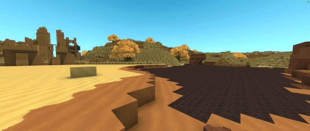
Drifting Plains
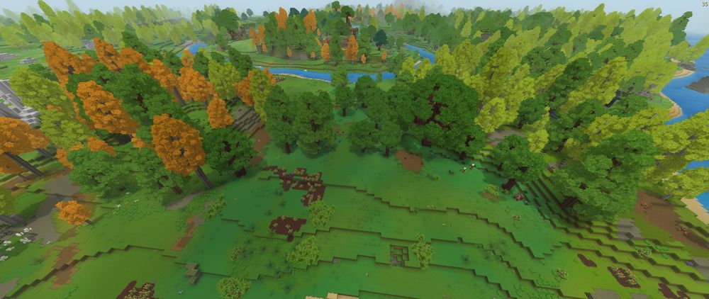
The Drifting Plains region is defined by gently rolling terrain and widespread tree cover spread across low-relief landforms. While the elevation remains relatively smooth, the landscape is heavily wooded, with forests stretching across hillsides and valleys rather than giving way to wide, open grasslands. Rivers and streams cut through the region, winding between forested areas and small clearings.
Compared to other regions, the Drifting Plains feels expansive not because it lacks trees, but because the land itself flows smoothly, with fewer sharp cliffs or extreme elevation changes. The result is a forested environment that feels navigable and cohesive, blending woodland visuals with flatter terrain.
Seedling Woods
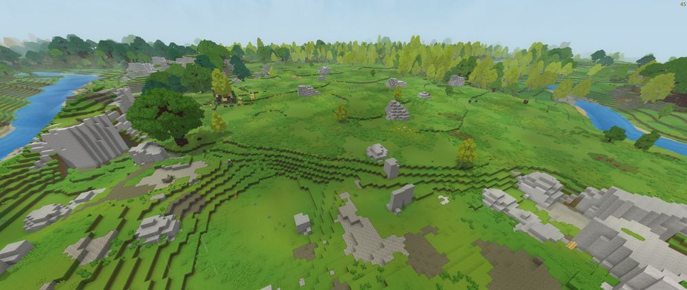
The Seedling Woods region is characterized by open grasslands dotted with young, widely spaced trees. Tree cover is present but sparse, allowing for long sightlines and an overall open feel across the landscape. Rather than dense forest, the region appears to represent early-stage woodland growth, where vegetation is still developing and the terrain remains largely unobstructed.
Gentle slopes, shallow valleys, and exposed stone outcrops break up the grassy terrain, giving the region a transitional quality between plains and more mature forested areas. The environment feels light and open, with trees acting as accents rather than defining features.
The Fens
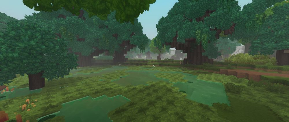
The Fens region is a wetland environment shaped by shallow water, saturated soil, and dense vegetation. Waterways weave through the region, forming ponds, marshes, and slow-moving channels that divide the land into irregular patches. Ground-level plants, reeds, and grasses dominate the terrain, reinforcing the region’s damp and heavy atmosphere.
In some areas, The Fens transitions into thick forested stretches where large trees cluster tightly around waterways. These forested sections form closed canopies above the wetlands, creating darker, more enclosed spaces without losing the underlying marshy character of the region. Elevation remains low and uneven, with moisture driving both terrain shape and plant growth.
Overall, The Fens blends wooded wetlands with open marshland, making it feel dense and enclosed in some areas while remaining water-focused throughout.
Zone 2 - Howling Sands
The Howling Sands is aligned with the Wind element and is defined by arid conditions and exposed landscapes. Regions within this zone emphasize erosion, open space, and minimal vegetation.
Golden Steppes
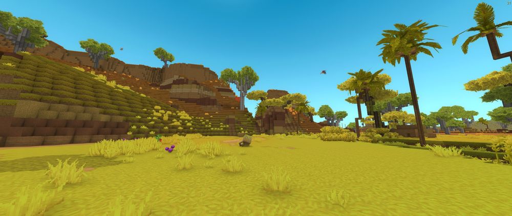
The Golden Steppes region is defined by open terrain, warm-toned ground cover, and gently rising plateaus broken up by shallow valleys. The landscape alternates between dry grassland and exposed earth, creating a patchwork of yellow and orange tones rather than uniform sand. Elevation changes are present but gradual, with broad slopes leading up to layered rock formations and mesas.
Vegetation is sparse but intentional. Short trees and scrub-like growth appear scattered across the region, often clustering near water sources or low-lying areas. Narrow rivers cut through the steppes, creating greener corridors that contrast sharply with the surrounding dry land. These waterways soften the environment without fully transforming it into fertile terrain.
Overall, the Golden Steppes feels transitional, sitting between open grassland and harsher desert regions. It is more structured and elevated than the Desolate Basin, but less eroded and hazardous than the Badlands, giving it a balanced, open character within the Howling Sands.
Badlands
The Badlands region is defined by dry, eroded terrain marked by layered hills, exposed stone, and sparse vegetation. The landscape is uneven and rugged, with stepped slopes and ridgelines forming natural terraces across the region. Plant life is limited, appearing mainly as scattered, hardy trees adapted to the dry conditions.
One of the defining features of the Badlands is the presence of tar pits. These dark, viscous pools interrupt the otherwise sandy and rocky terrain, creating stark visual contrast against the lighter ground. Tar pits appear sunken into the landscape, reinforcing the sense that the land has been shaped by erosion and long-term environmental stress.
Overall, the Badlands feels harsh and unstable, with terrain that emphasizes exposure and elevation rather than shelter. The combination of dry landforms, minimal vegetation, and hazardous tar pits clearly distinguishes the region from other environments within the Howling Sands.
Desolate Basin
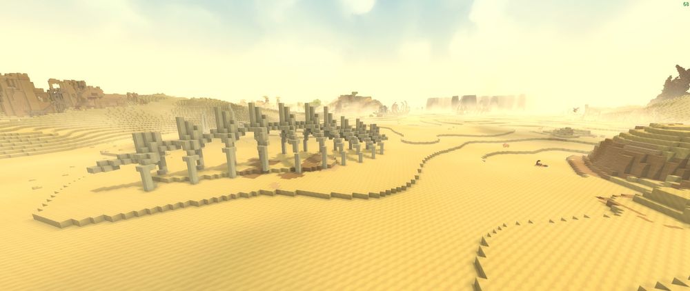
The Desolate Basin region is a vast, open desert defined by low elevation, sweeping sand fields, and minimal vertical terrain. Unlike the layered hills of the Badlands, the landscape here is broad and flattened, with shallow ridges and wind-carved patterns stretching across the basin floor. The terrain feels expansive and exposed, with long, uninterrupted sightlines in every direction.
Vegetation is extremely sparse. Small clusters of hardy plants and occasional skeletal remains break up the sand, but much of the region is dominated by open ground. Rock formations and structures appear infrequently and tend to rise gently from the surrounding terrain rather than forming sharp cliffs. The basin’s scale and emptiness are its defining traits, emphasizing distance and isolation over elevation or complexity.
Overall, the Desolate Basin feels barren and unprotected, reinforcing its role as one of the most inhospitable regions within the Howling Sands.
Zone 3 - Whisperfrost Frontiers
The Whisperfrost Frontiers represents the Water element through ice and cold climates. Regions within this zone emphasize snow, ice, and dramatic elevation.
Frostmarch Tundra
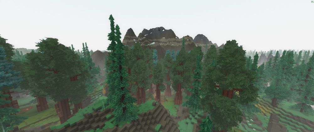
The Frostmarch Tundra region is a cold, mountainous environment defined by towering peaks, deep valleys, and extensive conifer forests. Rather than being a flat or uniformly frozen landscape, the region combines rugged elevation changes with dense redwood and fir forests that thrive despite the persistent cold. Snow coverage varies by elevation, appearing more heavily on exposed slopes and mountaintops while valleys and forest floors remain largely unfrozen.
Forested areas dominate much of the region, with tall, closely packed trees filling valleys and lower mountain slopes. These forests create enclosed, shadowed spaces, while surrounding ridgelines and peaks rise sharply above them. Rocky outcrops and exposed stone are common, reinforcing the region’s mountainous character. Atmospheric haze and distance fog further emphasize the cold climate and scale of the terrain.
Overall, Frostmarch Tundra is defined by cold influence rather than constant snow, blending alpine terrain with vast conifer forests. Mountains, forests, and open valleys coexist within the same region, unified by low temperatures, elevation, and seasonal extremes rather than a single surface appearance.
Boreal Reach
The Boreal Reach is a cold transitional region defined by a mix of open plains and conifer forests under persistent low temperatures. Unlike Frostmarch Tundra, which is dominated by mountainous terrain and dense fir and redwood forests, Boreal Reach is flatter and more open, with gentler elevation changes and wider sightlines.
Tree cover appears in clusters rather than continuous forests, allowing large stretches of open ground to break up the landscape. Snow coverage is intermittent, collecting in patches and along slopes, but does not form permanent ice or glacial features. The ground alternates between exposed earth, grass, and light snow, reinforcing the region’s role as a boundary between harsher cold environments and more stable terrain.
Overall, Boreal Reach feels cold but not extreme. Plains and forests coexist without heavy elevation or permanent ice, creating a region shaped by chill and seasonality rather than glaciation.
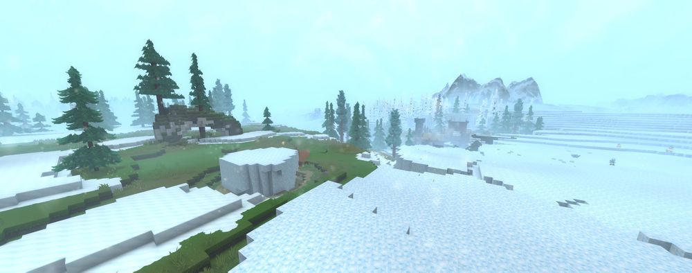
The Everfrost
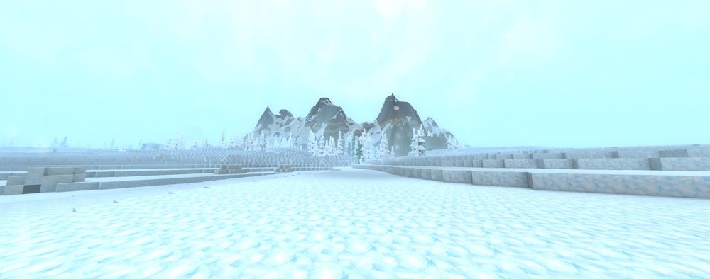
The Everfrost is an extreme cold region defined by permanent snow cover, ice-locked terrain, and minimal vegetation. Vast frozen plains stretch across the landscape, shaped by wind and snow into layered ridges and shallow depressions. The ground is uniformly white, with little visible soil or exposed earth, reinforcing the region’s inhospitable nature.
Vegetation is sparse and heavily altered by the cold. Trees appear infrequently and are coated in frost, often reduced to pale, frozen silhouettes rather than living forests. Where elevation rises, jagged mountain formations break through the snow, their dark rock faces partially buried beneath ice and drifted snow. These peaks dominate the horizon and emphasize the region’s severity.
Overall, The Everfrost feels barren, exposed, and unrelenting. Unlike Frostmarch Tundra or Boreal Reach, there is no sense of seasonal variation or transitional climate. Snow and ice define the region entirely, marking it as the most unforgiving environment within the Whisperfrost Frontiers.
Zone 4 - Devastated Lands
The Devastated Lands embodies the Fire element and reflects large-scale destruction rather than natural evolution. Regions within this zone are defined by heat, ash, and scorched terrain.
Cinder Wastes
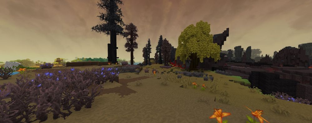
The Cinder Wastes are a transitional region shaped by lingering heat and long-term environmental damage. This area sits between fully devastated landscapes and more stable terrain, creating an open and exposed environment marked by ash-stained ground and scattered remnants of burned vegetation. The region feels stripped down and eroded, as if the land has already endured its destruction and is now slowly wearing away.
Vegetation is sparse and uneven throughout the Cinder Wastes. Blackened trees and brittle trunks stand far apart, with many reduced to skeletal forms. Some isolated growth remains, but it appears weak and discolored rather than alive or thriving. The overall color palette is dominated by muted yellows, browns, and dark grays, reinforcing the sense of decay and exhaustion across the landscape.
Lava flows and glowing fissures frequently border or cut through the region, introducing constant environmental danger without fully overtaking the terrain. These features suggest nearby volcanic activity while leaving much of the land in a scorched but cooling state. The ground itself appears fractured and worn, shaped by repeated stress rather than a single catastrophic event.
The Cinder Wastes feel abandoned rather than actively hostile. Where the Charred Woodlands convey violent destruction, this region represents what remains after the fire has passed. It serves as a bleak and unforgiving buffer within the Devastated Lands, defined by survival without recovery.
Charred Woodlands
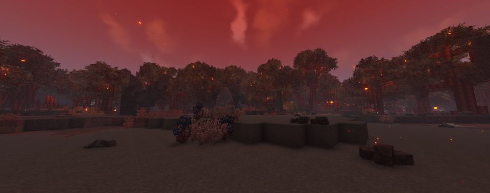
The Charred Woodlands are a scorched, hostile region shaped by fire and collapse. Once forested terrain has been burned down to blackened trunks, ash-covered ground, and smoldering debris. Dense stands of trees still remain, but they are twisted and dark, their leaves permanently singed and glowing faintly with embers. The air is heavy and hazy, muting the sky and casting the entire region in deep reds, blacks, and smoky grays.
The landscape itself is uneven and unstable. Large depressions and circular clearings break up the forest canopy, exposing cracked earth, collapsed terrain, and exposed stone. Pockets of lingering fire and molten light dot the ground, suggesting recent or ongoing destruction rather than ancient ruin. Visibility is limited, and the terrain feels claustrophobic despite its size.
Overall, the Charred Woodlands convey a sense of devastation rather than natural harshness. Unlike deserts or tundra shaped by climate, this region feels actively ruined; burned, broken, and dangerous to traverse. It stands as a visual marker of catastrophic events within the Devastated Lands, where survival is less about weather and more about enduring the aftermath of destruction.
Oceanic Environments
Oceans in Orbis function as expansive environmental regions rather than traditional zones. They exist alongside surface zones and often border or separate them, creating large aquatic spaces with their own terrain, depth, and exploration challenges. While oceans contain many individual underwater biomes, they are best understood as broad oceanic regions defined by depth, temperature, and proximity to land.
Shallow Seas
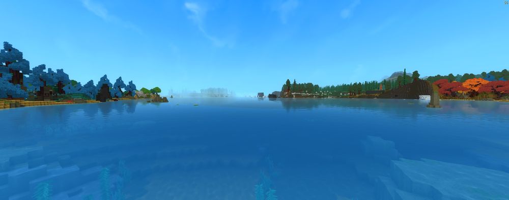
Shallow Seas are coastal regions found near shorelines and island chains. These areas are characterized by clearer water, visible seabeds, and gradual depth changes. Coral formations, reefs, and underwater vegetation are commonly depicted here, making these regions feel more vibrant and accessible than deeper waters.
Shallow seas often act as a transition between land and open ocean environments, visually connecting surface zones to aquatic exploration.
Open Ocean
The Open Ocean represents vast stretches of deep water far from land. These regions are defined by depth, limited visibility, and minimal terrain features near the surface. The environment feels expansive and isolating, with the seafloor often far below and largely unseen.
This region emphasizes scale and distance rather than dense environmental detail, giving the sense that the ocean is a world of its own.
Deep Ocean
The Deep Ocean exists as a distinct and extreme oceanic region and has been described by the developers as “a zone all by itself.” It represents the deepest parts of Orbis’ oceans, where light is scarce and the environment becomes increasingly alien.
Visually, the Deep Ocean is presented as darker and more mysterious that other aquatic regions, showing its separation from surface biomes and traditional zones. It functions as a standalone environment rather than a simple extension of coastal waters.
Conclusion
Orbis is full of places that look cool and try to kill you at the same time. Every area has its own terrain, surprises, and bad ideas waiting around corners. Learning what you are walking into makes a big difference between exploring and panicking. Take your time, watch your surroundings, and remember that most mistakes start with “I’ll be fine.”
Need Help?
If you have questions or run into any issues, our support team is here to help! Reach out using the support widget on our website or visit our support center for further assistance.